Smoky Mountains Vacation- Sylva,Bryson City,Franklin,Highlands,Cashiers,Cherokee, NC
Wesser Bald Lookout Tower
Categories: Hiking & Backpacking, Museums & Historic Sites, Appalachian Trail, Dog Friendly Hiking Trails, Backcountry Camping


Highlights
- Wesser Bald Lookout Tower's elevation is 4,627 feet
- Moderately strenuous hike through the Nantahala National Forest via the "Appalachian Trail"
- Two routes to choose from via Tellico Gap, North along the Appalachian Trail (see below)
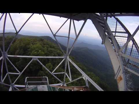
- Gorgeous 360 degree views in all directions of multiple mountain ranges and peaks
The Local Scoop
We recommend a hike to Wesser Bald Lookout Tower, an historic location on the Appalachian Trail, due to it's awesome views in every direction. From Wesser Bald, see the Great Smoky Mountains to the the North, the Balsam Mountains and the Cowees to the Northeast, the Little Tennessee River Valley to the East, the Nantahala Mountains to the South (Winespring Bald's radio/tv towers) and to the West the Valley River Mountains and the Snowbird Mountains towards Andrews and Robbinsville, NC. So, needless to say, take your binoculars!
If you're in the Franklin NC area, we suggest accessing the Appalachian Trail from Tellico gap, just outside of Franklin, NC. Take note that this is a long and windy/gravel road up to Tellico Gap.
From the trailhead at Tellico Gap/Appalachian Trail, you'll be heading North.
The Hike
**Two Choices - You'll have a couple of choices for accessing Wesser Bald Lookout Tower, and you'll notice them once you head North out of the parking lot. Your first choice is on your left, in the form of the Appalachian Trail. This route will be a bit more strenuous, due to some loose rocks and root exposure (normal for any portion of the A.T.). Your second choice is straight ahead, and is in the form of a forest road. This route will be less strenuous, and recommended for anyone with a need for an easier route.
The one-way hike is 1.4 miles, and once you reach the top, the challenge isn't over. Now, you have to climb the steep and somewhat intimidating staircase to the large platform atop Wesser Bald Lookout Tower. Be careful here, especially if the stairs are wet. The slow go wins the race. 360 degree views from the top are the ultimate reward!
About Getting There
After you turn onto Tellico Road from N.C. Hwy-28 you will wind your way along a paved state road until you reach the "Tellico Trout Farm." The road turns to gravel here and you'll need to keep going straight and past the farm. The road starts it's climb towards Tellico Gap and the large parking area for the trail after you have passed the large trout farm.
Once at the parking area and trailhead, you'll notice the "AT" goes South to your left and North to your right. Go right, North, to get to the lookout tower at Wesser Bald.
Enjoy the views!
The Local Directions
From Franklin, NC
Take N.C. Hwy-28 North for 12.1 miles to Tellico Road. Stay on Tellico Road for 9 more miles. At 3.7 miles on Tellico Road it will turn to gravel. Pass the Tellico Trout Farm on your Right and start the twisting climb to Tellico Gap and the rather large parking area for the "AT" and Wesser Bald access.
Difficulty Levels
- Hike7

- Coordinates
- Trailhead: 35.268115, -83.572496
Summit: 35.277049, -83.577354 - Access
- Difficult via NC Hwy-28/Tellico Road
Tellico Gap - Hike Distance
- 2.8 miles (roundtrip)
- Nearest City
- Franklin
- County
- Macon County
- Distance From
- NC Hwy-28, 8.3 miles
Franklin, 21.1 miles